File:Map congress of vienna.jpg
Map_congress_of_vienna.jpg (767 × 594 pixels, file size: 325 KB, MIME type: image/jpeg)
File information
Structured data
Captions
Captions
Add a one-line explanation of what this file represents

|
File:Europa 1815.svg is a vector version of this file. It should be used in place of this JPG file when not inferior.
File:Map congress of vienna.jpg → File:Europa 1815.svg
For more information, see Help:SVG.
|
Summary
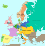
edit| DescriptionMap congress of vienna.jpg | Map of Europe, after the Congress of Vienna, 1815 |
| Date | |
| Source | The International Commission and Association on Nobility. Add today 2015, nov.29 some details & corrections in the Austrian & Ottoman empires, according with « Grosser Atlas zur Weltgeschichte » (H.E.Stier, dir.) Westermann 1985, ISBN 3-14-100919-8, « Putzger historischer Weltatlas Cornelsen » 1990, ISBN 3-464-00176-8, « Atlas des Peuples » of André & Jean Sellier, ed. La Découverte : « Europe centrale » : 1992, ISBN 2-7071-2032-4 and « Orient » : 1993 and ISBN 2-7071-2222-X ; « Történelmi atlasz a középiskolák számára », Kartográfiai Vállalat Szerkesztőbizottsága, Budapest 1991, ISBN 963-351-422-3. |
| Author | The International Commission and Association on Nobility |
| Permission (Reusing this file) |
Disclaimer from the website of The International Commission and Association on Nobility: "The pictures are not copyrighted. All pictures we use are in the public domain." |
| Other versions |
Derivative works of this file: Map congress of vienna-fr.png |
Licensing
edit| Public domainPublic domainfalsefalse |
| I, the copyright holder of this work, release this work into the public domain. This applies worldwide. In some countries this may not be legally possible; if so: I grant anyone the right to use this work for any purpose, without any conditions, unless such conditions are required by law. |
File history
Click on a date/time to view the file as it appeared at that time.
| Date/Time | Thumbnail | Dimensions | User | Comment | |
|---|---|---|---|---|---|
| current | 00:24, 3 December 2015 |  | 767 × 594 (325 KB) | Ras67 (talk | contribs) | cropped |
| 17:34, 29 November 2015 |  | 775 × 600 (296 KB) | Spiridon Ion Cepleanu (talk | contribs) | Add today 2015, nov.29 some details & corrections in the Austrian & Ottoman empires, according with « Grosser Atlas zur Weltgeschichte » (H.E.Stier, dir.) Westermann 1985, ISBN 3-14-100919-8, « Putzger historischer Weltatlas Cornelsen » 1990, ISBN... | |
| 16:58, 3 April 2013 |  | 775 × 600 (96 KB) | Lubiesque (talk | contribs) | Map corrected. Luxembourg was part of the German Confederation. | |
| 17:48, 20 November 2010 |  | 1,292 × 1,000 (356 KB) | P. S. Burton (talk | contribs) | {{Information |Description=Map of Europe, after the Congress of Vienna, 1815 |Source=[http://www.nobility-association.com/thecongressofvienna.htm The International Commission and Association on Nobility] |Date=2009 |Author=The International Commission and |
You cannot overwrite this file.
File usage on Commons
The following 2 pages use this file:
File usage on other wikis
The following other wikis use this file:
- Usage on ar.wikipedia.org
- Usage on az.wikipedia.org
- Usage on bn.wikipedia.org
- Usage on bn.wikibooks.org
- Usage on ca.wikipedia.org
- Usage on cs.wikipedia.org
- Usage on da.wikipedia.org
- Usage on en.wikipedia.org
- Usage on en.wikibooks.org
- Usage on eo.wikipedia.org
- Usage on es.wikipedia.org
- Usage on et.wikipedia.org
- Usage on fi.wikipedia.org
- Usage on fr.wikipedia.org
- Usage on hi.wikipedia.org
- Usage on hy.wikipedia.org
- Usage on id.wikipedia.org
- Usage on io.wikipedia.org
- Usage on it.wikipedia.org
- Usage on ja.wikipedia.org
- Usage on ka.wikipedia.org
- Usage on lv.wikipedia.org
- Usage on ms.wikipedia.org
- Usage on pl.wikipedia.org
- Usage on ro.wikipedia.org
- Usage on ru.wikipedia.org
- Usage on sco.wikipedia.org
- Usage on sh.wikipedia.org
- Usage on sv.wikipedia.org
- Usage on tr.wikipedia.org
- Usage on uk.wikipedia.org
View more global usage of this file.
Metadata
This file contains additional information such as Exif metadata which may have been added by the digital camera, scanner, or software program used to create or digitize it. If the file has been modified from its original state, some details such as the timestamp may not fully reflect those of the original file. The timestamp is only as accurate as the clock in the camera, and it may be completely wrong.
| User comments | rce: http://commons.wikimedia.org/wiki/File:Map_congress_of_vienna.jpg |
|---|---|
| Orientation | Normal |
| Horizontal resolution | 96 dpi |
| Vertical resolution | 96 dpi |
| Software used | Adobe Photoshop |
| File change date and time | 01:21, 3 December 2015 |
| Color space | Uncalibrated |

