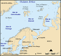
File:Karte Europäisches Nordmeer.png
From Wikimedia Commons, the free media repository
Jump to navigation
Jump to search

Size of this preview: 657 × 600 pixels. Other resolutions: 263 × 240 pixels | 526 × 480 pixels | 1,000 × 913 pixels.
Original file (1,000 × 913 pixels, file size: 291 KB, MIME type: image/png)
File information
Structured data
Captions
Captions
Add a one-line explanation of what this file represents
| DescriptionKarte Europäisches Nordmeer.png |
Deutsch: Karte vom Europäischen Nordmeer
English: Map of the Norwegian Sea |
||||||||
| Date | 11 February 2009 (upload date) | ||||||||
| Source |
self-made, using
|
||||||||
| Author | NordNordWest | ||||||||
| Permission (Reusing this file) |
I, the copyright holder of this work, hereby publish it under the following licenses:
You may select the license of your choice. |
||||||||
| Other versions |
[edit]
|

|
This map has been made or improved in the German Kartenwerkstatt (Map Lab). You can propose maps to improve as well.
azərbaycanca ∙ čeština ∙ Deutsch ∙ Deutsch (Sie-Form) ∙ English ∙ español ∙ français ∙ italiano ∙ latviešu ∙ magyar ∙ Nederlands ∙ Plattdüütsch ∙ polski ∙ português ∙ română ∙ sicilianu ∙ slovenščina ∙ suomi ∙ македонски ∙ русский ∙ ქართული ∙ հայերեն ∙ বাংলা ∙ ไทย ∙ +/−
|
File history
Click on a date/time to view the file as it appeared at that time.
| Date/Time | Thumbnail | Dimensions | User | Comment | |
|---|---|---|---|---|---|
| current | 12:40, 11 February 2009 |  | 1,000 × 913 (291 KB) | NordNordWest (talk | contribs) | + Lofoten |
| 11:51, 11 February 2009 |  | 1,000 × 913 (291 KB) | NordNordWest (talk | contribs) | {{Information |Description= {{de|Karte vom Europäischen Nordmeer}} {{en|Map of the Norwegian Sea}} |Source=self-made, using * Norwegian Sea blank map.png by Norma |
You cannot overwrite this file.
File usage on Commons
The following 30 pages use this file:
- User:NordNordWest/Gallery/Maps
- File:Bahari ya Barents.png
- File:Barents Sea map.png
- File:Barents Sea map GR.png
- File:Barents Sea map hr.svg
- File:Barents Sea map hu.svg
- File:Barents Sea map ru.svg
- File:Barents sea map blank.png
- File:Barents sea map de.png
- File:Barents sp.png
- File:Carte de la mer de Norvège-Jan-Mayen-localisation.png
- File:Carte de la mer de Norvège.png
- File:Karte Europäisches Nordmeer.png
- File:Norra meri.png
- File:Norveško more.svg
- File:Norvég-tenger térkép 2.png
- File:Norvég tenger térkép.png
- File:Norwegian Sea blank map.png
- File:Norwegian Sea map-da.png
- File:Norwegian Sea map.png
- File:Norwegian Sea map ce.svg
- File:Norwegian Sea map ch.png
- File:Norwegian Sea map cs.png
- File:Norwegian Sea map it.png
- File:Norwegian Sea map mk.svg
- File:Norwegian Sea map no.png
- File:Norwegian Sea map ru.svg
- File:Norwegian Sea map sv.png
- File:Norwegian Sea map uk.svg
- Template:Other versions/Norwegian Sea


