Atlas of India

|
Wikimedia Commons Atlas of the World The Wikimedia Atlas of the World is an organized and commented collection of geographical, political and historical maps available at Wikimedia Commons. Discussion • Update the atlas • Index of the Atlas • Atlas in categories • Other atlases on line |
|
| ||||||||||||||||||||||||||||||||||||||
General maps

|
Map of India |

|
India and surrounding countries |

|
South Asia in local languages |

|
Physical map |

|
Physical map of India with various physiographic divisions |
Maps of divisions
This section holds maps of the administrative divisions.

|
States and union territories of India |

|
Districts of India |

|
Disputed territories of India |
History maps
This section holds a short summary of the history of the area of present-day India, illustrated with maps, including historical maps of former countries and empires that included present-day India.

|
Indus Valley Civilisation (2600-1900 BCE) |

|
Vedic period (1500-500 BCE) |

|
Vedic period |

|
Bhāratavarṣa (India) as mentioned in the Mahabharata and the Ramayana |

|
Ancient India (600 BC) |

|
Gandhara |

|
Magadha (500 BCE) |

|
Nanda Dynasty (400 BCE) |

|
Mauryan Empire |

|
Location of Buddhist missionaries sent by Ashoka Maurya |
| [[|border|251x400px]] | Mauryan Empire (250 BCE) |

|
Mauryan Empire |

|

|
Mauryan Empire |

|
Mauryan Empire |

|
Mauryan Empire (in blue) under Dashratha Maurya on a modern map of India |

|
Gupta Empire |

|
Category:Satavahana empire |

|
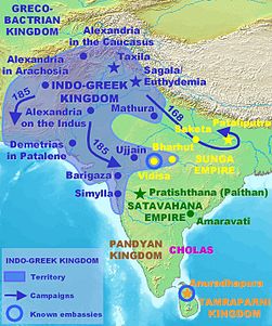
Indo-Greek kingdom (180 BCE-10 CE) |

|
Indo-Greek Kingdom |

|
Indo-Greek Kingdom |

|
Indo-Greek Kingdom |

|
Kalinga |

|
Kushan Empire |

|
Western Kshatrapas(35-405 AD) |
| [[|border|251x400px]] | Chera Dynasty |

|
Pandyas (100-1250) |

|
Gupta Empire (400 AD) |

|
Gupta Empire |

|
Gupta Empire |

|
Gupta Empire |

|
Kalabhras (400) |

|
Kadamba Empire (450) |

|
Hephthalite dominion (520) |

|
Harsha's Empire around 600 |

|
Pallava (645) |

|
Pratihara (6th-11th century) |

|
Rajput Kingdoms (7th-11th Century) |

|
Pala Empire (700-1200) |

|
Kanauj Empire (750-900) |

|
Rashtrakuta Empire (750-900) |

|
Chola Empire (1050) |

|
Chola Empire |

|
Chola Empire |

|
Chola Empire |

|
Chalukya (735-1120) |

|
Rashtrakuta (780) |

|
Rashtrakuta (780) |

|
Rastrakuta (735-982) |

|
Western Chalukyas (973-1200) |

|
Hoysala Empire (1000-1346) |

|
Vijayanagara Empire (1336-1646) |

|
Delhi Sultanate (13th century) |

|
Delhi Sultanate during the Tughlaq dynasty 1320-1330 |

|
Delhi Sultanate under Iltutmish |

|
South India in 1500 |

|
Kingdom of Mysore (1400-1947) |

|
Sher Shah's Empire (around 1500) |

|
European settlements in India 1501-1739 |

|
Mughal Empire (1600) and European possesions |

|
Mughal Empire in 1605 |

|
Mughal Empire (1526-1857) |

|
Mughal Empire |

|
Mughal Empire |

|
Maratha Empire, 1680 |

|
Mughal Empire 1690 |

|
India 1700-1792 |

|
French India 1741-1754 |

|
Maratha Confederacy in 1794 |

|
Maratha Confederacy (yellow), Sikh Empire (green) and British India (red), 1805 |

|
British India in 1909 |

|
Anglo-Mysore Wars |

|
Anglo-Mysore Wars |

|
Anglo-Mysore Wars |

|
Indian Rebellion of 1857 |

|
Britain's holdings on the Indian subcontinent were granted independence in 1947 and 1948, becoming four new independent countries: India, Burma (now Myanmar), Ceylon (now Sri Lanka) and Pakistan (including East Pakistan, modern-day Bangladesh) |
Old maps
This section holds copies of original general maps more than 70 years old.

|
Hindustan in 1812 by Arrowsmith and Lewis |

|
Map of Bengal 1893 |

|
Map of Eastern Bengal and Assam 1907 |
Ethno-linguistic maps
| Languages of South Asia |
| Indo-Aryan languages |
| Dravidian languages |
| Cultural regional areas |
| Hindi Belt |
| Literacy rate |
| Literacy rate |
Other maps
| Geology map |
| Hills of India |
| Rivers of India |
| Rivers and lakes of India |
| Annual rainfall |
| Indian Summer |
| Wind Zone map |
| Natural hazards |
| Temperature map |
| Population density |
| Decadal growth rate |
| Air and seaports |
| Geological map |
| Climatic zones |
| Annual rainfall |
| Average annual temperature |
| Climatic disaster risk |
| Earthquake zones |
| Flood zones |
| Sex ratio |
| Jewish communities |
| Railways |
satellite-maps
| Satellite map |
Notes and references
|
General remarks:
|

