Abstract
Free full text

Walking the Line: Conducting Transect Walks in Burkina Faso
Abstract
In this article we present results from transect walks and participatory mapping done in Burkina Faso. Since the Sahelian drought of the 1970s, researchers have continued to depict the Sahelian region of West Africa as an environment experiencing severe degradation; a narrative that persists over time. Recently, however, analyses of satellite imagery have identified remarkable patterns of greening across the Sahel. The causes of this greening are hotly debated. Through this project we aim to inform these debates with on-the-ground perceptions of local farmers and pastoralists. The transect walk method is a community-based process that collects information on the land-use/land-cover (LULC) features across villages. Transects help triangulate data by combining high-resolution satellite imagery, firsthand observations, and local experiences of ecological processes. We describe the methodology behind transects and discuss how they contextualize an otherwise removed process of environmental analysis. We also describe the challenges that arise throughout the fieldwork process.
Introduction
We describe the process of conducting participatory mapping methods in Burkina Faso to understand local perceptions of vegetation change. Researchers have long considered regions of Burkina Faso to be degraded. Satellite images show recent increases in greening, that is, positive vegetation change in areas once degraded. The authors worked as part of a research team to understand what contributes to greening from the bottom-up. We conducted fieldwork during the summer of 2019 in communities that practice rainfed agriculture. One goal of this study was to understand local views on vegetation trends across two regions experiencing different environmental conditions.
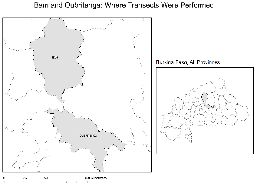
We conducted fieldwork with support from the National Science Foundation (NSF) studying the human role in vegetation trends in West Africa. We piloted participatory mapping methods in Bam and Oubritenga Provinces in Burkina Faso (see Figure 1). In this article, we describe village transect walks and reflect on the process of conducting them. We discuss how transect data complements ethnographic research and describe obstacles and lessons learned during the process. We frame the larger project to highlight the techniques farmers in West Africa use to adapt to environmental challenges. This paper shares what we learned about doing this research so that local stakeholders, NGOs, and researchers in West Africa can apply these methods in new contexts to solve local problems. We begin by providing background information about the project.
Background
Our NSF project is titled “Factors Influencing Vegetation Trends in Dryland Zones,” with Colin Thor West (Anthropology—UNC) and Aaron Moody (Geography—UNC) as Principal Investigators (PIs) who are leading the project. The Sahel (Arabic for “shore”) is the transition zone between the Sahara Desert in the north and the Sudanian savanna in the south. The region has been the subject of numerous debates since severe droughts occurred in the 1970s and 1980s, leading to widespread famine (Franke and Chasin 1980). These droughts and famines in the Sahel famously gave rise to the global scientific term “desertification” due to the work of Jules Charney (1975). Recently, however, environmental scientists have identified instances of greening in the Sahel using satellite data. These positive vegetation trends are particularly apparent in northern Burkina Faso (Herrmann, Anyamba, and Tucker 2005). For this project, we did something that has been left out of such studies on Sahelian greening—we worked with local farmers to understand vegetation trends from their perspective. We grounded these greening patterns by working with local rural producers to understand the processes driving them from their point of view.
In the 1980s, government agencies and international donors promoted Soil and Water Conservation (SWC) projects in provinces surrounding Kongoussi (Bam Province), which prompted hundreds of villages in the north of the country to rehabilitate degraded soils. Thus, we addressed two related questions given this historical context: (1) Are SWC practices contributing to greening? and (2) How do local community members perceive vegetation changes?
In their groundbreaking work, Fairhead and Leach (1996) underscored the importance of integrating ethnographic fieldwork with analyses of satellite imagery. We build on their insights by working with communities and analyzing high-resolution satellite imagery, using local narratives and perceptions to understand vegetation trends. To answer our questions, we conducted transect walks to ask people about their village landscapes, SWC techniques used, and local perceptions of greening and browning (Mahiri 1998; Okoba and de Graaff 2005). Transect walks are a common method in conservation biology (Walpole and Sheldon 1999) and are used in participatory rural appraisal methods to uncover local information across landscapes (Chambers 1994). Transect walks involve walking in a straight line for a pre-defined distance, recording geographic coordinates every fifty meters or so, and writing down the kinds of environmental features around that point.
We conducted transect walks in nine different communities. We chose communities in Kongoussi in the Bam Province because of the appearance of degradation in satellite imagery. In contrast, we chose communities in Ziniaré in the Oubritenga Province because of the appearance of greening. We were intrigued by these differences and wondered if local perceptions of greening and land degradation differed between these two provinces.
Participatory Mapping: Village Transect Walks
When a snake slithers into your backyard, your eyes see it first and assess the related danger. Information is sent to the brain who decides the appropriate action to take. Then, the arms receive instructions from the brain to grab a tool and to execute actions accordingly.
—Parable told by Koffi Nomedji before participatory mapping workshops, 2019
Nomedji’s (the second author) parable of eyes and arms offers valuable insights into our approach to collaborating with communities. We served as the “eyes,” collecting information so research organizations can learn from farming communities actively engaged in agriculture and SWC practices. Later, it will be up to the state or development institutions to use our academic research to make informed decisions. They can choose to work toward empowering field technicians to act in communities. Just like the eyes cannot take on the role of the arms, we were limited in our role and could not offer any technical assistance or develop any project. In Kongoussi, we worked with a local NGO named Zood-Nooma who has worked closely with villages across the north. It was easier for people in Kongoussi to understand that our fieldwork was strictly research as they were accustomed to projects launched by Zood-Nooma. In Ziniaré, some community leaders assumed that we were there to start a development project, which we frequently had to clarify using the parable above. We emphasized this since we, as anthropologists, were aware of the problematic legacies of research and its tendencies to overlook the immediate interests of local communities; a challenge which participatory research methods are designed to overcome (Cochran et al. 2008).
We worked with coordinators in both Kongoussi and Ziniaré, a community member from each village, and a field assistant to collect coordinates using a handheld GPS device. All coordinators, participants, and field assistants were compensated in CFA francs for their time. Coordinators were essential to help us contact and recruit community members, organize workshops, and to identify individuals to help during transects. They also played a key role in helping us translate French into Mooré, the local language, when working with community members. Our field assistant had many years of experience doing fieldwork and could operate the GPS device as well as take photos of terrain around coordinate points.
To choose a transect path, we used a satellite image printed on a large cloth and worked with community members to identify a path through a portion of the landscape. We selected a path based on two criteria. First, the line had to contain variable soil types, vegetation, and apparent land use. Second, the path had to be feasible to walk. Overall, our aim was to choose an accurate representation of the area to capture as much environmental variation as possible. Transects were between one and two kilometers long. Once we chose a starting point and a straight line, a local community member guided us through the village and assisted us during the transect walk.
Walking the Line
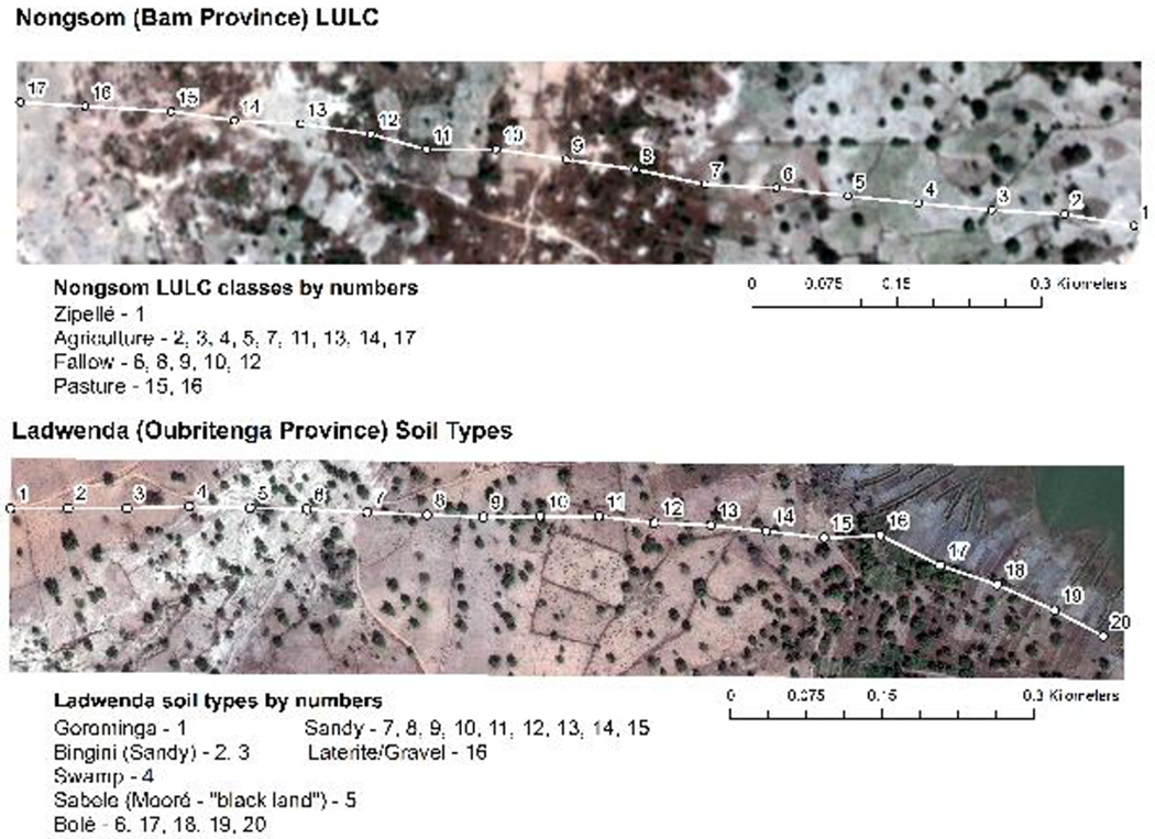
Most times, walking the transect line fell on the coordinator or the village member because of their deep knowledge of the terrain. This person was in charge of leading the rest of the team on a linear path. They kept the same direction and stopped every fifty steps (roughly 50 meters). The walk passed through different types of terrain including bushes, farms, muddy lowlands, mounds of granite rock, and marshes (see Figure 3). It was important for the individual walking the transect to maintain the same direction by standing still at each point thereby avoiding deviations to ensure it was as straight as possible. At each stop, our field assistant used a Garmin GPS device to capture longitude and latitude points and snap photos of the surrounding terrain. The device encoded each photo with the latitude/longitude coordinates so that researchers could bring them into a GIS program and map them.
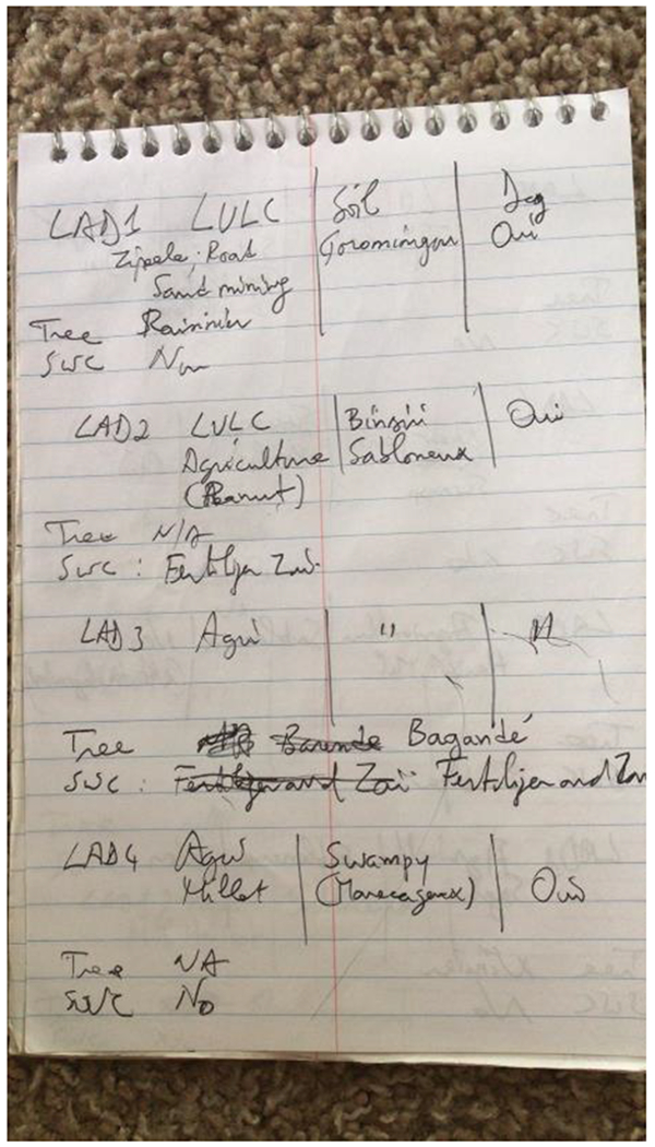
At each point, we asked the community member about soil type, terrain characteristics, vegetation, and whether the community member perceived the locale as degraded or not. Even if it was evident to us, we asked whether SWC techniques were used in certain areas and, if so, what kind. Lastly, we identified the most prominent bush or tree within a ten-meter radius. After taking handwritten notes in the field, we entered them into an Excel spreadsheet format (compare Figure 2 and Table 1). Community members answered these questions in their native language, Mooré, so they could elaborate and respond more extensively to our questions. When possible, we always asked for the local Mooré name for soil, land use, and bush/tree types. For each transect, one graduate student asked questions while the other took short notes.
Table 1:
Adaptation of hand-written notes to table. Mooré terms with translation provided: Zipellé (Mooré– “Bare soil”) and Sabélé (Mooré– “”black land”). “DEG” means “degraded.”
| ID_CODE | LULC | SOIL | DEG | TREE | SHRUB | SWC | SWC_TYPE |
|---|---|---|---|---|---|---|---|
| LAD_1 | Zipellé | Gorominga | Yes | Raisinier | Yes | ||
| LAD_2 | Agriculture | Bingini | Yes | Yes | Fertilizer/Zaï | ||
| LAD_3 | Agriculture | Bingini | Yes | Baganda | Yes | Fertilizer/Zaï | |
| LAD_4 | Agriculture | Swamp | Yes | No | |||
| LAD_5 | Zipellé | Sabélé | Yes | No |
Challenges and Lessons Learned
We encountered several farmers in their fields while conducting the transects. They were usually welcoming and even offered to assist when our coordinator explained the purpose of our visit. We once, however, walked too close to a settlement of Fulani pastoralists who questioned our motives, and we needed to rely on our guide to explain the situation.
We also found it challenging to choose a transect path that included a lot of variability. While the satellite image appeared to reflect different terrains, it did not necessarily reflect differences in land use. For example, in Nongsom (Figure 3), points 4, 7, and 14 appeared to be different but were all agriculture. Thus, our attempt to capture variability in land-use/land-cover (LULC) types was not always successful.
Additionally, transects could be physically demanding despite our best efforts to make them manageable. Days were often hot, transects could cut through elevated terrain and bush, and it involved walking a relatively long distance. Also, timing the transects around rainy periods was not always easy. If it rained recently, physically navigating the path was difficult due to slippery clay, mud, and flowing water.
Other difficulties included eliciting questions in a way that allowed community members to be as specific as possible. Some responses were ambiguous and would reflect previous land use as opposed to current. For example, some respondents would tell us an area was agriculture and then deliberate and say that it is currently jachère (fallow). Thus, we had to be precise when asking questions to minimize confusion.
Transects often cut through local farms. Stepping on growing plants became a risk. Even if most farmers gave us permission to cross, we usually avoided this risk by going around vulnerable shoots. Since we are not farmers, we had difficulty distinguishing young sorghum shoots from weeds. The transect leader was fortunately able to avoid stepping on plants as much as possible.
On one transect, we ran into a barrage (marsh near a reservoir) where people were farming, women were drawing water, and a group of cows and bulls were grazing. The straight line took us too close to a bull that became more hostile as we approached. We ended the transect at the previous point walk lest we were charged by the bull. Instead, we chose a proxy GPS point about thirty meters away and asked the community member about our desired point. Later, we plan to interpolate our intended point by using this proxy.
Combining Transect Data with Satellite Imagery
Once our fieldwork concluded, we uploaded the coordinate points into ESRI’s ArcMap (v. 10.5) software and spatially overlaid them with the satellite imagery. We sampled pixels around the points, labeled them, and performed a supervised classification that classifies other areas on the image according to similarities and differences in spectral characteristics among the samples. This process allowed us to produce a new, classified image where each pixel in the satellite image corresponded to a land-use/land-cover class. This process occurred without the participation of community members. Since classification techniques often mis-classify areas, producing error, having community members participate in this aspect of research could help create more accurate maps.
Results and Conclusion
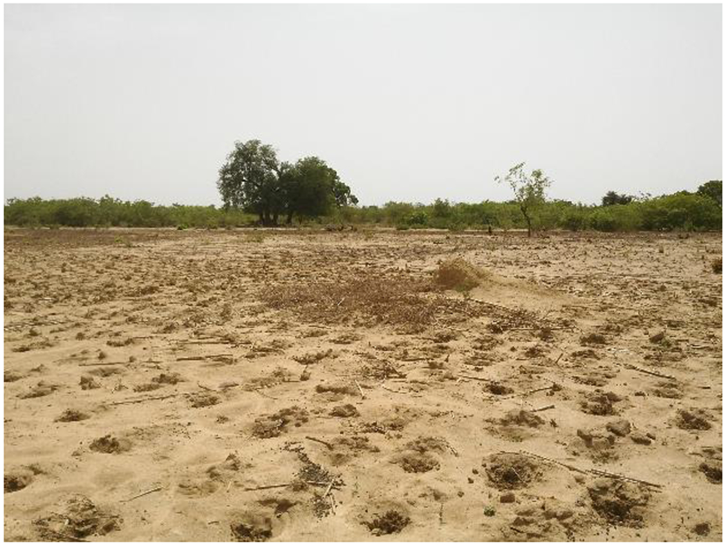
Overall, transects allowed us to understand spatial data from the perspective of local community members (Fairhead and Leach 1996). For example, learning local names for both vegetation and soil allowed us to classify satellite images using locally defined categories. Additionally, community members were able to distinguish between terrain that we could not decipher from satellite images alone. For instance, fallow areas and agriculture were very difficult to distinguish from the satellite image, and participatory mapping through transect walks allowed us to overcome this barrier. Lastly, transects revealed that representations of Burkina Faso as degraded were not accurate, and greening patterns appeared to be patchy throughout each community as a result of SWC practices. We learned about SWC practices like zaï, an indigenous technique where people dig shallow holes into a field to fill it with compostable material (see Figure 4). We also saw diguettes (semi-permeable rock dams) that prevent soil erosion and trap nutrients in the ground, leading to healthier soils.
Transects are an excellent participatory method to learn about land-use and land-cover as well as tap into local perceptions of environmental change. This method requires collaboration among community members and researchers to uncover detailed information about local environments. While transects offer a straightforward way to assess environmental conditions, they come with physical and logistical challenges. These challenges are outweighed by the numerous insights transects bring into local experiences and environmental contexts.
Acknowledgements
Support for fieldwork, imagery, and analysis was provided by the National Science Foundation Cultural Anthropology Program (BCS-1759064). The Carolina Population Center at University of North Carolina at Chapel Hill provided general support through its NIH Center grant (P2C HD050924).
Biographies
Alfredo Rojas is a Ph.D. Candidate in Anthropology at the University of North Carolina at Chapel Hill. He researches environmental change in West Africa, focusing on cash crop production in Côte d’Ivoire.
Koffi Nomedji is a Ph.D. Candidate in Cultural Anthropology at Duke University. He is currently doing fieldwork on local communities’ adaptation to coastal erosion in southern Togo (West Africa).
Colin Thor West is an Associate Professor in Anthropology and the Environment, Ecology, and Energy Program (E3P) at the University of North Carolina at Chapel Hill. He has worked in West Africa as a Peace Corps Volunteer and anthropologist since 1994.
Contributor Information
Alfredo Rojas, University of North Carolina at Chapel Hill.
Koffi Nomedji, Duke University.
Colin Thor West, University of North Carolina at Chapel Hill.
References Cited
- Chambers Robert., 1994. The Origins and Practice of Participatory Rural Appraisal. World Development 22(7):953–969. [Google Scholar]
- Charney Jules G., 1975. Dynamics of Deserts and Drought in the Sahel. Quarterly Journal of the Royal Meteorological Society 101(428):193–202. [Google Scholar]
- Cochran Patricia A. L., Marshall Catherine A., Garcia-Downing Carmen, Kendall Elizabeth, Cook Doris, McCubbin Laurie, and Gover Reva Mariah S.. 2008. Indigenous Ways of Knowing: Implications for Participatory Research and Community. American Journal of Public Health 98(1):22–27. [Abstract] [Google Scholar]
- Fairhead James, and Leach Melissa. 1996. Misreading the African Landscape: Society and Ecology in a Forest-Savanna Mosaic. Cambridge, United Kingdom: Cambridge University Press. [Google Scholar]
- Franke Richard W., and Chasin Barbara H.. 1980. Seeds of Famine: Ecological Destruction and the Development Dilemma in the West African Sahel. Montclair, NJ: Allanheld, Osmun, and Co. [Google Scholar]
- Herrmann Stefanie M., Anyamba Assaf, and Tucker Compton J.. 2005. Recent Trends in Vegetation Dynamics in the African Sahel and Their Relationship to Climate. Global Environmental Change 15(15):394–404. [Google Scholar]
- Mahiri Ishmail O., 1998. The Environmental Knowledge Frontier: Transects with Experts and Villagers. Journal of International Development 10(4):527–537. [Google Scholar]
- Okoba Barrack O., and de Graaff Jan. 2005. Farmers’ Knowledge and Perceptions of Soil Erosion and Conservation Measures in the Central Highlands, Kenya. Land Degradation and Development 16(5):475–487. [Google Scholar]
- Walpole Matthew J., and Sheldon Ian R.. 1998. Sampling Butterflies in Tropical Rainforest: An Evaluation of a Transect Walk Method. Biological Conservation 87(1):85–91. [Google Scholar]
Full text links
Read article at publisher's site: https://doi.org/10.17730/0888-4552.43.1.18
Read article for free, from open access legal sources, via Unpaywall:
https://www.ncbi.nlm.nih.gov/pmc/articles/PMC8550581
Citations & impact
Impact metrics
Citations of article over time
Article citations
Pathways of exposure to Vibrio Cholerae in an urban informal settlement in Nairobi, Kenya.
PLOS Glob Public Health, 4(8):e0002880, 20 Aug 2024
Cited by: 0 articles | PMID: 39163285 | PMCID: PMC11335117
Lessons from participatory community mapping to inform neglected tropical disease programmes in Nigeria.
Int Health, 15(suppl 1):i6-i17, 01 Mar 2023
Cited by: 1 article | PMID: 36960807 | PMCID: PMC10037265
Assessing soil erosion risk in a peri-urban catchment of the Lake Victoria basin.
Model Earth Syst Environ, 9(2):1633-1649, 29 Oct 2022
Cited by: 0 articles | PMID: 36341043 | PMCID: PMC9616704
'You want to deal with power while riding on power': global perspectives on power in participatory health research and co-production approaches.
BMJ Glob Health, 6(11):e006978, 01 Nov 2021
Cited by: 23 articles | PMID: 34764147 | PMCID: PMC8587355
Similar Articles
To arrive at the top five similar articles we use a word-weighted algorithm to compare words from the Title and Abstract of each citation.
Participatory Mapping with High-resolution Satellite Imagery: A Mixed method Assessment of Land Degradation and Rehabilitation in Northern Burkina Faso.
J Ecol Anthropol, 22(1):1-19, 01 Jan 2020
Cited by: 0 articles | PMID: 34650337 | PMCID: PMC8513720
Ground-truthing Sahelian Greening: Ethnographic and Spatial Evidence from Burkina Faso.
Hum Ecol Interdiscip J, 45(1):89-101, 05 Jan 2017
Cited by: 3 articles | PMID: 31371846 | PMCID: PMC6675452
A study of climate change and anthropogenic impacts in West Africa.
Environ Sci Pollut Res Int, 14(3):182-189, 01 May 2007
Cited by: 15 articles | PMID: 17561777
Participatory Mapping with Herders in a Climate Adaptation Research Project.
Pract Anthropol, 43(1):25-29, 08 Jan 2021
Cited by: 1 article | PMID: 34539062 | PMCID: PMC8443242
Funding
Funders who supported this work.
NICHD NIH HHS (2)
Grant ID: P2C HD050924
Grant ID: R24 HD050924


