| dbo:abstract
|
- Cima Tosa (3173 m n. m.) je hora v pohoří Brenta v severní Itálii. Nachází se v oblasti Tridentsko-Horní Adiže. Hora je tvořena, stejně jako celé pohoří, převážně vápenci. Cima Tosa je nejvyšší bod Brenty. (cs)
- Die Cima Tosa (3133,5 m s.l.m.) ist nach der Cima Brenta der zweithöchste Gipfel der Brentagruppe in den südlichen Kalkalpen der italienischen Provinz Trient. Vor dem Abschmelzen ihrer Eiskuppe wurde ihre Höhe mit 3173 m s.l.m. angegeben. Die Cima Tosa steht im zentralen Brentahauptkamm und begrenzt das Hochtal Val Brenta alta nach Süden. Der leichteste Zustieg erfolgt von Osten vom Sentiero dell' Ideale (Abzweig auf ca. 2700 m).Die Cima-Tosa-Nordeisrinne ist einer der bekanntesten klassischen Eisanstiege der Ostalpen. (de)
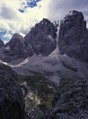
- Cima Tosa is a mountain in the Brenta group (It.: Dolomiti di Brenta), a subgroup of the Rhaetian Alps in the Italian Region of Trentino-Alto Adige, with a reported height of 3,136 metres (10,289 ft). it is the second highest peak of the Brenta group in the southern limestone Alps after the Cima Brenta. The height of the summit marked on the IGM maps is 3173 m, which would make it the highest peak in the Brenta Dolomites. An electronic measurement campaign in 2015 determined the new height. The change could be linked to the partial melting of the ice cap that covers it. Being the second highest peak of the Brenta group also changed Cima Tosa's prominence making its prominence 589 m above the Bocca di Brenta. The mountain rises above Val Rendena with its 800-metre (2,600 ft) vertical north face with a steep couloir called Canalone della Tosa dividing it from its ante-peak, Crozzon di Brenta. The summit is topped by a snow cupola above the rock face, almost like a shaven head, hence the name Cima Tosa (Iocal dialect: Shaven Summit). The south-eastern side descends in a series of snowy terraces and vertical rock pillars. (en)
- La Cima Tosa est un sommet des Alpes, à 3 173 m, point culminant du massif de Brenta, en Italie (Trentin-Haut-Adige). (fr)
- La Cima Tosa (3173 m s.l.m.) è una montagna delle Alpi Retiche meridionali. È la vetta più alta delle Dolomiti di Brenta, 23 metri più alta della cima Brenta (3151 m). (it)
- Cima Tosa – szczyt w Dolomitach Brenty, części Alp Wschodnich. Leży w północnych Włoszech w regionie Trydent-Górna Adyga. Jest to najwyższy szczyt Dolomitów Brenty. Na południe od Cima Tosa nie ma już wyższych szczytów, więc przy dobrej widoczności ze szczytu roztaczają się rozległe widoki, między innymi na masyw Adamello-Presanella i jezioro Garda. Pierwszego wejścia 20 lipca 1865 r. dokonał G. Loss. (pl)
- 托薩峰(義大利語:Cima Tosa),是意大利的山峰,位於該國北部,由特倫蒂諾-上阿迪傑大區負責管轄,屬於里申阿爾卑斯山脈的一部分,海拔高度3,173米,人類在1865年7月18日首次登上該山峰。 (zh)
|
| dbo:elevation
| |
| dbo:firstAscentYear
| |
| dbo:locatedInArea
| |
| dbo:mountainRange
| |
| dbo:prominence
| |
| dbo:thumbnail
| |
| dbo:wikiPageExternalLink
| |
| dbo:wikiPageID
| |
| dbo:wikiPageLength
|
- 9084 (xsd:nonNegativeInteger)
|
| dbo:wikiPageRevisionID
| |
| dbo:wikiPageWikiLink
| |
| dbp:easiestRoute
|
- Via Normale from east (en)
|
| dbp:elevationM
| |
| dbp:firstAscent
| |
| dbp:labelPosition
| |
| dbp:listing
|
- (en)
- 180000.0 (dbd:second)
|
| dbp:location
| |
| dbp:mapCaption
|
- Location in the Alps (en)
|
| dbp:name
| |
| dbp:photo
|
- Brentei-Hütte 039.jpg (en)
|
| dbp:photoCaption
|
- Cima Tosa and Crozzon di Brenta (en)
|
| dbp:photoSize
| |
| dbp:prominenceM
| |
| dbp:range
| |
| dbp:wikiPageUsesTemplate
| |
| dct:subject
| |
| gold:hypernym
| |
| georss:point
|
- 46.15555555555556 10.871944444444445
|
| rdf:type
| |
| rdfs:comment
|
- Cima Tosa (3173 m n. m.) je hora v pohoří Brenta v severní Itálii. Nachází se v oblasti Tridentsko-Horní Adiže. Hora je tvořena, stejně jako celé pohoří, převážně vápenci. Cima Tosa je nejvyšší bod Brenty. (cs)
- Die Cima Tosa (3133,5 m s.l.m.) ist nach der Cima Brenta der zweithöchste Gipfel der Brentagruppe in den südlichen Kalkalpen der italienischen Provinz Trient. Vor dem Abschmelzen ihrer Eiskuppe wurde ihre Höhe mit 3173 m s.l.m. angegeben. Die Cima Tosa steht im zentralen Brentahauptkamm und begrenzt das Hochtal Val Brenta alta nach Süden. Der leichteste Zustieg erfolgt von Osten vom Sentiero dell' Ideale (Abzweig auf ca. 2700 m).Die Cima-Tosa-Nordeisrinne ist einer der bekanntesten klassischen Eisanstiege der Ostalpen. (de)
- La Cima Tosa est un sommet des Alpes, à 3 173 m, point culminant du massif de Brenta, en Italie (Trentin-Haut-Adige). (fr)
- La Cima Tosa (3173 m s.l.m.) è una montagna delle Alpi Retiche meridionali. È la vetta più alta delle Dolomiti di Brenta, 23 metri più alta della cima Brenta (3151 m). (it)
- Cima Tosa – szczyt w Dolomitach Brenty, części Alp Wschodnich. Leży w północnych Włoszech w regionie Trydent-Górna Adyga. Jest to najwyższy szczyt Dolomitów Brenty. Na południe od Cima Tosa nie ma już wyższych szczytów, więc przy dobrej widoczności ze szczytu roztaczają się rozległe widoki, między innymi na masyw Adamello-Presanella i jezioro Garda. Pierwszego wejścia 20 lipca 1865 r. dokonał G. Loss. (pl)
- 托薩峰(義大利語:Cima Tosa),是意大利的山峰,位於該國北部,由特倫蒂諾-上阿迪傑大區負責管轄,屬於里申阿爾卑斯山脈的一部分,海拔高度3,173米,人類在1865年7月18日首次登上該山峰。 (zh)
- Cima Tosa is a mountain in the Brenta group (It.: Dolomiti di Brenta), a subgroup of the Rhaetian Alps in the Italian Region of Trentino-Alto Adige, with a reported height of 3,136 metres (10,289 ft). it is the second highest peak of the Brenta group in the southern limestone Alps after the Cima Brenta. (en)
|
| rdfs:label
|
- Cima Tosa (en)
- Cima Tosa (cs)
- Cima Tosa (de)
- Cima Tosa (fr)
- Cima Tosa (it)
- Cima Tosa (pl)
- 托薩峰 (zh)
|
| owl:sameAs
| |
| geo:geometry
|
- POINT(10.87194442749 46.155555725098)
|
| geo:lat
| |
| geo:long
| |
| prov:wasDerivedFrom
| |
| foaf:depiction
| |
| foaf:isPrimaryTopicOf
| |
| foaf:name
| |
| is dbo:highest
of | |
| is dbo:wikiPageDisambiguates
of | |
| is dbo:wikiPageWikiLink
of | |
| is dbp:highest
of | |
| is foaf:primaryTopic
of | |


